
How to Walk to Prospect Point
I’ve had Stanley Park in my backyard for the last 15 years and walking its 20km+ trail network is a favourite pastime (see: this post, this one, and this one). Following that hike up with a pint from the Prospect Point Cafe, which is now open again, is another favourite.
The great thing about Stanley Park’s trails is that they’re all on Google Maps, so really, you don’t need this blog post for me. However if you’re reading this, you probably Googled how to walk to Prospect Point so I shall deliver instructions based on some of my favourite paths:
How to Walk to Prospect Point
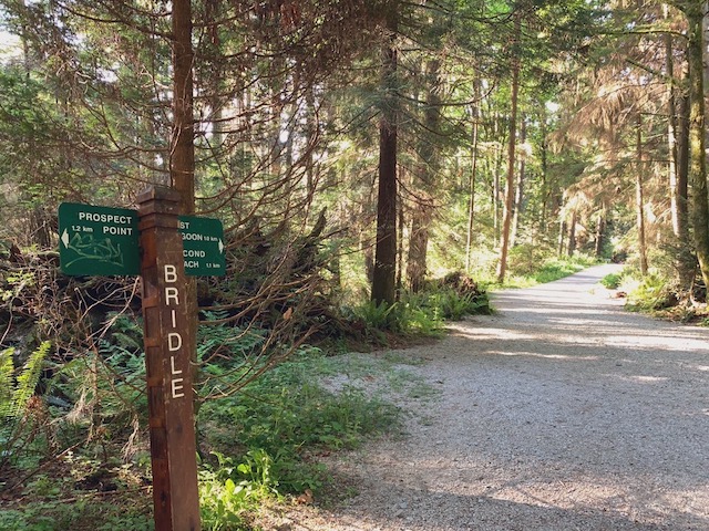
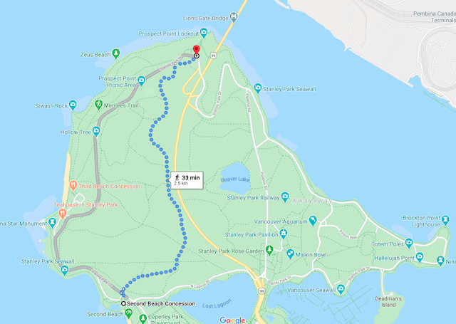
From the Second Beach – Bridle Path
Distance: 2.5km
Elevation Gain: 60m
Estimated Walk Time: 33 mins
This is probably the most direct route since the Bridle Path will take you almost the whole way, it just dips to the right where it turns into the Prospect Point Trail at the top. The Bridle Path starts right behind the Second Beach Concession, on the other side of Park Drive. Bridle Path will get you there from a few other entry points.
From Lost Lagoon – Tatlow Walk to Bridle
Distance: 2.2km
Elevation Gain: 72m
Estimated Walk Time: 30 mins
If you’re coming from the West End, walk around to the north side of Lost Lagoon, just west of the Causeway. Cross N Lagoon Drive and take the Tatlow Walk to Bridle, to Prospect Point Trail.
From the #19 Bus Loop/Rose Garden – The Creek Trails
Distance: 2.4km
Elevation Gain: 58m
Estimated Walk Time: 31 mins
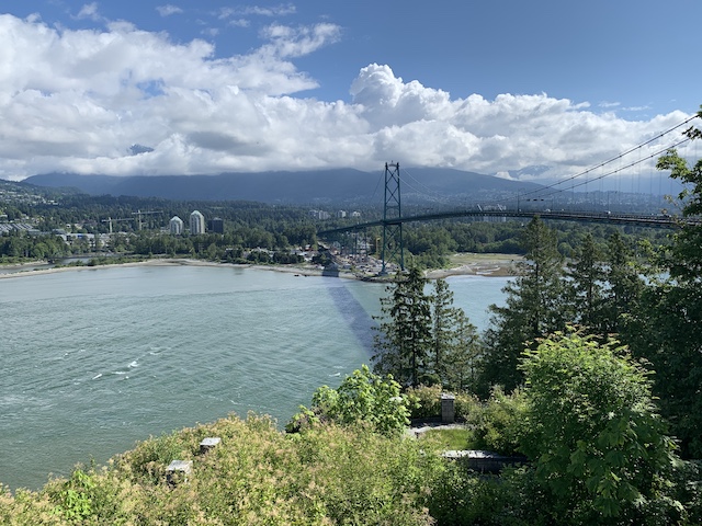
If you’re coming from the bus loop, the Pavilion, or the Rose Garden, you can enter the trail network from the South Creek Trail (near the Shakespeare Garden). There are a few more turns on this route, from South Creek to Beaver Lake, head west then cross Lake Trail to join up with North Creek Trail. At the top of North Creek you will join up with Stanley Park Drive and walk across the overpass where many photos like this are taken:

From the Seawall – Since there’s quite an elevation gain, there are a few trails up from the Seawall but they’re much more steep than the other entry points. However, they’re there so here’s how to get up to the point:
From the Seawall’s north east side, hop onto the Avison Trail, near the intersection of Pipeline Road and Stanley Park Drive, which will wind you right up to the top. There’s an unnamed path that branches off to take you under the Lions Gate, which will get you there in 700m. If you take Avison all the way up to the overpass, it’s a 1.2km route.
From the Seawall’s north west side, walk up from the Third Beach concession where you’ll find three options: There is a Third Beach Trail which will lead to Stanley Park Drive, which you can cross at Hollow Tree, take Rawlings Trail, and join up with Bridle Path.
Merilees will take you to a fork in the path, you can take the lower route (Siwash Rock Trail) which is very up and down but also very scenic and worth the rollercoaster climb. Merilees, right at the fork, takes a higher route. Both are 1.6-1.8km with 20-22 mins to reach Prospect Point.
There are many, many combinations of routes to take in the park but these are just some of my favourites, and some of the most direct.


1 Comment — Comments Are Closed
We live on the North Shore so We park at Park Royal and walk across Lions Gate Bridge. A fantastic walk, beautiful views, Free parking