4sharesThe Vancouver Maritime Museum was built around the RCMP vessel the St. Roch, a National Historic Site in Canada, in 1959. The building’s shape, reflecting the boats that surround it in the nearby marina and waters of the Salish Sea, tell of what treasures can be found within and make it a fitting subject for […]
Continue reading this post
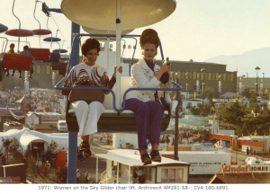
5.0KsharesThe City of Vancouver Archives has digitized over 8,000 images from the Pacific National Exhibition (“PNE”) thanks to funding from the British Columbia History Digitization Program. These images are easy to view, re-use, and share. Additionally, they have digitized another 874 images under copyright which can be viewed via the Archives. 1971: Women on the […]
Continue reading this post
2sharesDine Out Vancouver returns January 16 to February 1, 2015 with more than 70 food-themed events, 25 hotels offering special room rates and packages, a record-setting 277 restaurants dishing up prix fixe menus at $18, $28 and $38 price points. A big part of Dine Out Vancouver over the years has been its events and […]
Continue reading this post
198sharesGet away for one night of magic on stage combined with stay at an award-winning boutique hotel in the heart of Yaletown! Disney’s Beauty and the Beast, the the smash hit Broadway musical, is coming to Vancouver in February and I’ve partnered with the show and the world renown OPUS Hotel to offer you the […]
Continue reading this post
1shareThe Vancouver Maritime Museum is hosting a special event for families to meet a popular character who lives in a pineapple under the sea. SpongeBob SquarePants will be in Vancouver for the first time ever on Saturday, January 17th to promote the new 3D movie, “The SpongeBob SquarePants Movie: Sponge Out of Water”, which hits […]
Continue reading this post
 Canada Together in Vancouver July 1st
 Vancouver International Children's Festival Lineup
 Vancouver Canadians Promotional Schedule 2025