
Top 5 Rainy Day Hikes Near Vancouver
Contributed by Stephen Hui
In “Raincouver,” April showers don’t always bring May flowers. However, wet weather represents a golden opportunity to find solitude in the rainforests around Vancouver. Why not don waterproof-breathable gear and ever-so-fashionable gaiters, pack the 10 essentials, leave a trip plan with a reliable person, and get outside?
Here are 5 rainy day picks from my new guidebook, 105 Hikes in and around Southwestern British Columbia, published by Greystone Books.
Top 5 Rainy Day Hikes Near Vancouver
Please respect the backcountry by practicing Leave No Trace techniques
1. Gold Creek
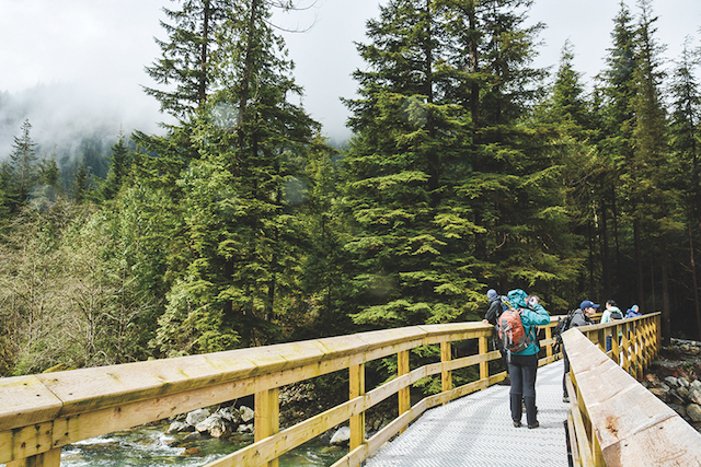
Gold Creek bridge on the East-West Canyon Connector. Photo by Stephen Hui.
A bridge over Gold Creek makes possible an attractive loop at Golden Ears Provincial Park in Katzie First Nation territory. This outing includes visits to the scenic backcountry campsites at Viewpoint Beach and Alder Flats.
The East Canyon Trail starts at the Gold Creek parking lot. Stay with the old logging road as it descends to Gold Creek and intersects the East-West Canyon Connector. Before crossing the Gold Creek footbridge, continue upstream to Viewpoint Beach.
Back at the bridge, go west on the East-West Canyon Connector. Turn right on the watery, rooty (and snowy in spring) West Canyon Trail. Turn around at Alder Flats, and stick with the West Canyon Trail. Turn left on the Menzies Trail and cross the bridge on the Golden Ears Parkway to return to the parking lot.
Round trip: 14km, 4.5 hours. Elevation gain: 340m. Access: Dewdney Trunk Road and 232 Street, Maple Ridge.
2. Norvan Falls
At Lynn Headwaters Regional Park — in Musqueam, Squamish, and Tsleil-Waututh territories — you’re likely to encounter various fungi and rusty logging relics. From the park entrance, cross Lynn Creek, and fill out a form at the hiker registration kiosk. Go north on the Lynn Loop Trail and continue onto the pretty Cedars Mill Trail.
Join the northern portion of the Headwaters Trail. Ignore the Coliseum Mountain turnoff. Detour left to check out the nifty suspension bridge over Norvan Creek. (Do not continue into the Hanes Valley without the requisite knowledge, experience, and gear.)
Upstream at Norvan Falls, signs warn hikers to keep back from the cliff. After lunch, retrace your steps to the entrance.
Round trip: 14km, 5 hours. Elevation gain: 210m. Access: Trans-Canada Highway 1 and Lynn Valley Road, North Vancouver.
3. Teapot Hill
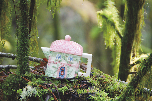
One of many teapots in Cultus Lake Provincial Park. Photo by Stephen Hui.
The ceramic scenery of the Teapot Hill Trail offers cupfuls of fun for kids and adults alike. Add in the old-growth Seven Sisters for a sweet all-season outing. Both points of interest lie in Cultus Lake Provincial Park, outside Chilliwack in Soowahlie territory.
From the Entrance Bay campground, dive into the forest on the Seven Sisters Trail. Continue south and turn left on a connector, near the Clear Creek campground. Go right on the Cultus Lake Horse Trail, right at the next fork, and left on Road 918 to get on the Teapot Hill Trail. A fenced lookout delivers vistas of the Columbia Valley and Vedder Mountain.
Back at the bottom of the hill, turn right on Road 918 to see more of the woods. Turn around at the Road 918–Watt Creek intersection. Keep right at two junctions to stay on the Horse Trail. Retrace your steps to the trailhead.
Distance: 13km, 5 hours. Elevation gain: 255m. Access: Trans-Canada Highway 1, No. 3 Road, and Cultus Lake Road, Abbotsford.
4. West Knob
Whyte Lake and the West Knob are found in Musqueam, Squamish, and Tsleil-Waututh territories. From the Westport Road trailhead, head under the Nelson Canyon Bridge. Go right on the Trans Canada Trail.
Soon the Whyte Lake Trail leaves to the left. Visit the dock and turn right at the outhouse to join the Baden-Powell Trail in the woods above the lake. Where an old metal plate indicates “Eagle Ridge” lies farther on the B-P, go left on the rough Donut Rock Trail.
At the next junction, head left and up to the West Knob viewpoint. Look out over Howe Sound (Atl’Kitsem to the Squamish Nation). Return the way you came. Dogs must be on-leash at Whyte Lake.
Distance: 12km, 5 hours. Elevation gain: 610m. Access: Trans-Canada Highway 1 and Westport Road, West Vancouver.
5. Triangle Lake
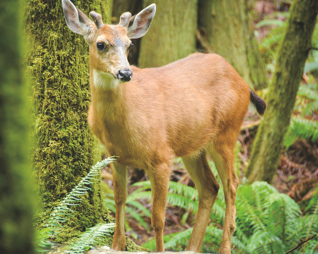
Black-tailed deer, spotted from the Colvin Creek Trail. Photo by
Stephen Hui.
Located in Sargeant Bay Provincial Park, Triangle Lake is a bog known as s-ch’ewk’ (a reference to frybread) to the shíshálh Nation. From Redrooffs Road, go right on the Colvin Creek Trail. Cross a bridge by a waterfall and head north into the mossy forest.
Stay right for the Triangle Lake Trail. Keep right to reach Triangle Lake. Head counterclockwise on the Triangle Lake Circle Trail. The wetland flora include bog cranberry, Labrador tea, and shore pine. Retrace your steps to the trailhead.
Round trip: 8km, 3 hours. Elevation gain: 185m. Access: Highway 101 and Redrooffs Road, Sechelt.
Stephen Hui is the author of 105 Hikes in and around Southwestern British Columbia, a new guide from Greystone Books.


2 Comments — Comments Are Closed
Thanks for sharing, Rebecca! Happy trails.
Thank you so much for acknowledging the First Nations territories of these trails!